What are the different flood hazard zone designations shown on a Flood Insurance Rate Map (FIRM), and what do they mean for anyone buying real estate in Charleston, SC or you just found that perfect home for sale in Myrtle Beach? We’ll here’s the “low down” on what to look for and what it means.
The zone designations shown on the “FIRMs” are defined below.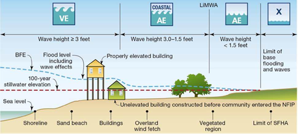
Zone A
Zone A is the flood insurance rate zone used for 1-percent-annual-chance (base flood) floodplains that are determined for the Flood Insurance Study (FIS) by approximate methods of analysis. Because detailed hydraulic analyses are not performed for such areas, no Base Flood Elevations (BFEs) or depths are shown in this zone. Mandatory flood insurance purchase requirements apply.
Zone AE and A1-A30
Zones AE and A1-A30 are the flood insurance rate zones used for the 1-percent-annual-chance floodplains that are determined for the FIS by detailed methods of analysis. In most instances, BFEs derived from the detailed hydraulic analyses are shown at selected intervals in this zone. Mandatory flood insurance purchase requirements apply. AE zones are areas of inundation by the 1-percent-annual-chance flood, including areas with the 2-percent wave runup, elevation less than 3.0 feet above the ground, and areas with wave heights less than 3.0 feet. These areas are subdivided into elevation zones with BFEs assigned. The AE zone will generally extend inland to the limit of the 1-percent-annual-chance Stillwater Flood Level (SWEL).
Zone AH
Zone AH is the flood insurance rate zone used for areas of 1-percent-annual-chance shallow flooding with a constant water-surface elevation (usually areas of ponding) where average depths are between 1 and 3 feet. BFEs derived from detailed hydraulic analyses are shown at selected intervals within this zone. Mandatory flood insurance purchase requirements apply.
Zone AO
AO zones are areas of sheet-flow shallow flooding where the potential runup is less than 3.0 feet above an overtopped barrier crest (ΔR<3.0 feet). The sheet flow in these areas will either flow into another flooding source (AE zone), result in ponding (AH zone), or deteriorate because of ground friction and energy losses and merge into the X zone. AO areas are designated with 1-, 2-, or 3-foot depths of flooding.
Zone AR
Zone AR is the flood insurance rate zone used for areas protected by flood-control structures, such as levees, that are being restored. FEMA will consider using the Zone AR designation if the flood protection system has been deemed restorable by a Federal agency in consultation with a local project sponsor; a minimum level of flood protection is still provided to the community by the system; and restoration of the flood protection system is scheduled to begin within a designated time period and in accordance with a progress plan negotiated between the community and FEMA. Mandatory purchase requirements for flood insurance apply in Zone AR, but the rate will not exceed that of an unnumbered Zone A, if the structure is built in compliance with Zone AR floodplain management regulations.
For floodplain management in Zone AR areas, the property owner is not required to elevate existing structures when making improvements. However, new structures must be elevated (or floodproofed for nonresidential structures) so that the lowest floor, including the basement, is at least 3 feet above the highest adjacent existing grade, if the BFE does not exceed 5 feet at the proposed development site. For infill sites, rehabilitation of existing structures, or redevelopment of previously developed areas, there is a 3-foot elevation requirement regardless of the depth of the BFE at the project site.
The Zone AR designation will be removed and the restored flood-control system will be shown as providing protection from the base flood on the National Flood Insurance Program (NFIP) map when the restoration project is complete and all the necessary data have been submitted to FEMA.
Zone A99
Zone A99 is the flood insurance rate zone used for areas within the 1-percent-annual-chance floodplain that will be protected by a Federal flood-protection system, where construction has reached specified statutory milestones. No BFEs or depths are shown in this zone. Mandatory flood insurance purchase requirements apply.
Zone D
The Zone D designation is used for areas where there are possible but undetermined flood hazards. In areas designated as Zone D, no analysis of flood hazards has been conducted. Flood insurance is optional and available, and the flood insurance rates for properties in Zone D are commensurate with the uncertainty of the flood risk.
Zone V and V1 – 30
Zone V and V1 – 30 designation is for coastal areas with a 1-percent or greater chance of flooding and an additional velocity hazard associated with storm waves (wave action). Because detailed hydraulic analyses are not performed for such areas, no BFEs or depths are shown in this zone. Mandatory flood insurance purchase requirements apply.
Zone VE
VE zones are coastal high hazard areas where wave action and/or high-velocity water can cause structural damage during the base flood. They are subdivided into elevation zones with BFEs assigned. VE zones are identified using one or more of the following criteria for the base flood conditions:
- The wave runup zone occurs where the (eroded) ground profile is 3.0 feet or more below the 2-percent wave runup elevation
- The wave overtopping splash zone is the area landward of the crest of an overtopped barrier, in cases where the potential 2-percent wave runup exceeds the barrier crest elevation by 3.0 feet or more(ΔR>3.0 feet). (See Subsection D.2.8.2.)
- The breaking wave height zone occurs where 3-foot or greater wave heights could occur (this is the area where the wave crest profile is 2.1 feet or more above the total stillwater level).
- The primary frontal dune zone, as defined in 44 CFR Section 59.1 of the NFIP regulations.
For the Pacific Coast only:
- The high-velocity flow zone is landward of the overtopping splash zone (or area on a sloping beach or other shore type), where the product of depth of flow times the flood velocity squared (hv2) is greater than or equal to 200 ft3/sec2.
Zone B and X (shaded)
Zones B and X (shaded) are areas of 0.2-percent-annual-chance floodplain, areas of 1-percent-annual-chance (base flood) sheet flow flooding with average depths of less than 1 foot, areas of base flood stream flooding with a contributing drainage area of less than 1 square mile, or areas protected from the base flood by levees. No BFEs or depths are shown in this zone, and insurance purchase is not required
Zones C and X (unshaded)
Zones C and X (unshaded) are flood insurance rate zones used for areas outside the 0.2-percent-annual-chance floodplain. No BFEs or depths are shown in this zone, and insurance purchase is not required.
(This information is taken from FEMA publications and is intended as a limited explanation of Flood Zones Rules – Please seek qualified advice from your engineer, surveyor or attorney before making a decision to purchase property in a flood zone.)
Need more help? Feel free to contact us or give us a call. Our agents have experience and the contacts to make sure you know what you are buying.